
 English
  Español
“Shadow UAS training” by U.S. ARMY FORT HUACHUCA is licensed under CC BY-NC 2.0 (photo by Lara Poirrier, Fort Huachuca Public Affairs).
Alanna Riggs, Fort Huachuca Sentinel Landscape Partnership Coordinator
The Sentinel Landscapes Partnership was established in 2013 by the Departments of Defense, Agriculture and Interior in order to strengthen military readiness, support agricultural economies, and protect and conserve natural resources. Since its inception, the Partnership has become a broad coalition of federal agencies, state and local governments, non-governmental organizations and landowners working towards these objectives. To date, there are seven designated Sentinel Landscapes each associated with a base installation: Joint Base Lewis-McChord, WA, est. 2013, Fort Huachuca, AZ, est. 2015, Middle Chesapeake, MD, est. 2015, Avon Park Air Force Range, FL, est. 2016, Camp Ripley, MN, est. 2016, Eastern North Carolina, est. 2016 and Georgia, est. 2018.
While the three founding agencies oversee the Partnership, each Sentinel Landscape is predominantly a local initiative. Each Sentinel Landscape relies on the surrounding communities to tackle conservation and restoration projects on the ground. Local participation helps promote land management practices that most benefit their region.
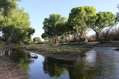
Bureau of Land Management’s San Pedro Riparian National Conservation Area (photo by June Lowery, BLM).
The Fort Huachuca Sentinel Landscape Partnership (FHSLP) was formed in 2015 with Fort Huachuca as the base installation. This Army installation boasts the premier restricted military airspace for unmanned aircraft systems training in the Western U.S. and supports operations for the U.S. Air Force, Marine Corps, and Border Patrol. The 1.6M acre Sentinel Landscape footprint covers Fort Huachuca’s Buffalo Soldier Electronic Test Range: an electronically quiet region buffered on all sides by Arizona’s Sky Islands.
Land ownership within the landscape is diverse, and is made up of 32% private lands, 30% State Trust Lands, 25% U.S. Forest Service, 8% Bureau of Land Management, and 5% military. The diversity in land ownership is reflected within the Partnership, with all parties striving to address critical regional issues. The FHSLP’s objectives are to preserve the working and rural character of the landscape, strengthen the economies of farms, ranches and forests, conserve habitats and natural resources, and protect vital test and training missions conducted by Fort Huachuca. A Strategic Plan, completed in 2018, identifies three key issues within the landscape: open space and working lands, threatened, endangered and at-risk species, and wildfire and hazardous fuels.
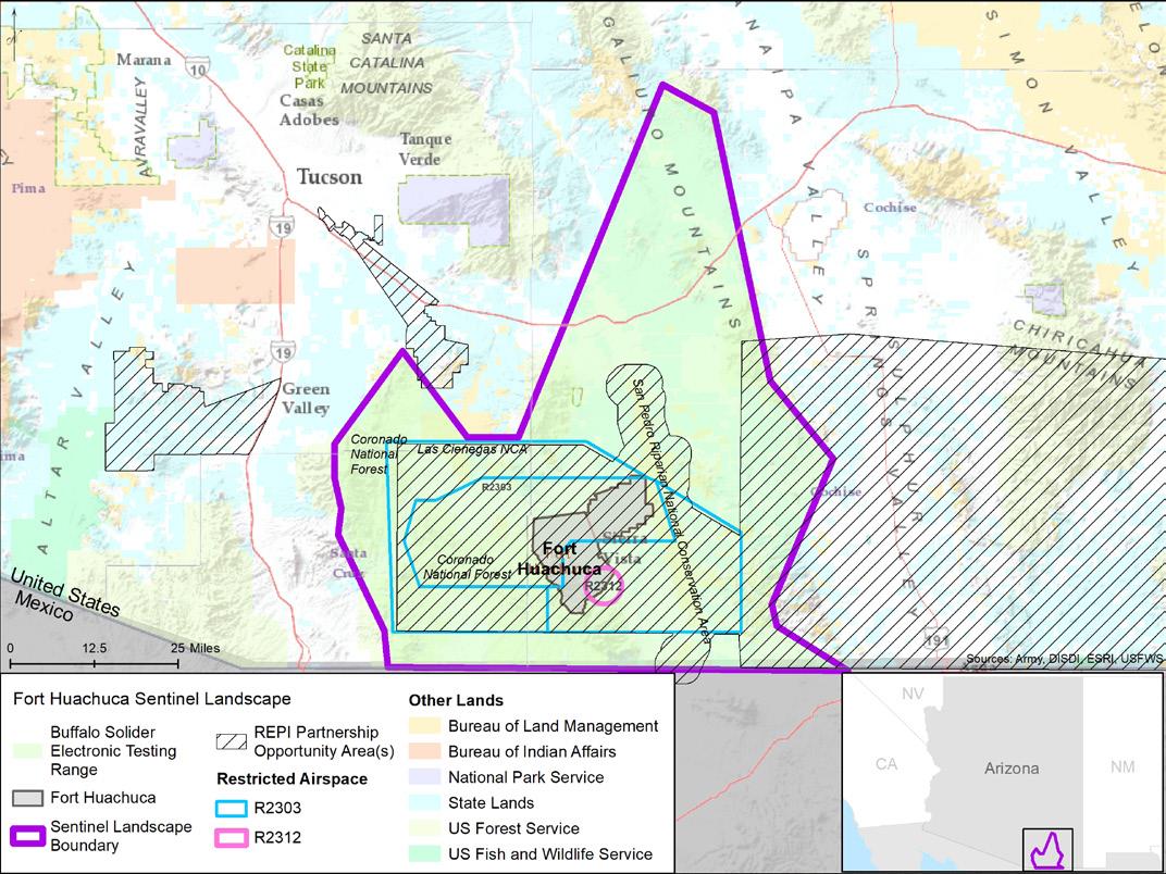
Fort Huachuca Sentinel Landscape Boundary map (repimap.org).
The FHSL, situated among Arizona’s Sky Islands, expansive grasslands, and rare riparian areas, make this an incredibly diverse landscape. The FHSLP is working collectively to improve habitat and population numbers for 14 federally listed T&E species, as well as several state listed at-risk species. Partners work with willing landowners, the U.S. Fish and Wildlife Service, Arizona Game and Fish Department, and Fort Huachuca to minimize impacts and implement recovery plans. Implementation Plan objectives include the identification of water conservation opportunities to maintain water flow in springs, seeps, streams and rivers, and the conservation of critical habitat for listed and at risk species through conservation easements.
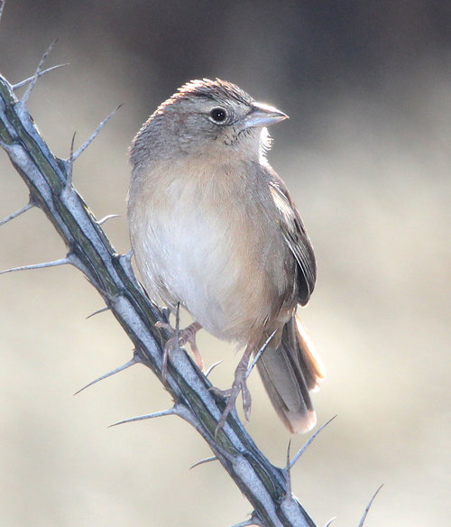
A Botteri’s Sparrow perches on Ocotillo in southeast Arizona is licensed under CC0 1.0 (photo by Alan Schmierer).
While grasslands dominate the Fort Huachuca Sentinel Landscape, their condition varies across the region due to habitat loss, fragmentation, and invasive species. Even so, they provide essential habitat for species like pronghorn antelope and grassland birds. Species of concern and priority to the Sonoran Joint Venture include Botteri’s Sparrow, Baird’s Sparrow, Chestnut-collared Longspur, and Sprague’s Pipit, whose numbers have declined largely due to habitat loss and modification. At Audubon’s Appleton-Whittell Research Ranch, “scientists monitor grassland wildlife and test ways to eliminate invasive non-native grasses. Since 1969 it has served as an ungrazed reference area that can be compared with grasslands more directly managed by humans.”
The threat of wildfire is one of the major risks to the Fort, public land managers, and private landowners within the Sentinel Landscape; threatening lives, property, and cultural and natural resources. Agencies, counties, and communities work collaboratively at a landscape-scale to reduce hazardous fuels, restore habitat, manage any wildfires, and share resources.
Since it’s designation in 2015, the partners of the Fort Huachuca Sentinel Landscape have spent $31M on projects. FHSL and its partners have protected 63K acres of private land through conservation easements, and enrolled 271K acres of private and federal lands in federal or state programs that provide financial or technical assistance that promote sustainable agriculture, restore imperiled species, or preserve natural resources. To learn about specific projects and partnerships across the FHSLP, check out the detailed map.